Industrial
If you need a site to build a facility or are looking for an existing building for your business, Stark County has an expansive inventory from which to choose. Your SEDB team will assist your business with the site review and selection process that will give you all the advantages you need to perform at the highest level. Cost, utilities, access to transportation and a business friendly environment will give you an advantage over the competition when you make Stark County your home.
New
Vacant Land
411 Oberlin Ave SW
Massillon, OH 44647
Stark County
Min Size: 5 acres
Max Size: 490.10 acres
Massillon, OH 44647
Stark County
Min Size: 5 acres
Max Size: 490.10 acres
Vacant Land
Massillon Energy & Technology Park
| General Site Overview | |
|---|---|
| Site Name (if any) | Massillon Energy & Technology Park |
| Site Address | 411 Oberlin Ave SW |
| City | Massillon |
| County (where site is located) | Stark |
| Zip Code | 44647 |
| Latitude | 40.7790 |
| Longitude | -81.5225 |
| Site Owner | Massillon Energy & Technology Park LLC |
| Ownership Type | Private |
| ZoomProspector Link | View Property https://properties.zoomprospector.com/OHIO/property/admin/d1f76af9-0b7f-4f61-8b6e-256919cb57d2 |
| Site Information | |
|---|---|
| Lot Size | 485.75 acres |
| Total Site Acreage | 485.75 acres |
| Maximum Contiguous Developable Acreage | 485.75 acr |
| Divisible? | Yes |
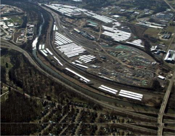
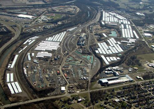
| Current Use | Rail served yard and vacant land |
| Previous Use | Steel complex - buildings razed |
| Zoning | Heavy Industrial |
| Flood Plain | No |
| Flood Plain Comments | Percent in Flood Plain: 0 % |
| Available for Purchase? | Yes |
| Price/Acre | $2,000 to $5,000 per acre per year |
| Sale Terms | Land lease from $2,000 to $5,000 per acre per year depending on size and /or location of property within complex. |
| Property Description | Former steel complex that is repurposed for rail served yard area and possible build to suit leaseback options. Served by Norfolk Southern and R J Corman railroads with a dedicated interior short line rail with six miles of track. Good access to SR 21 - US 30 interchange. |
| Environmental/Due Diligence | |
|---|---|
| Phase I Complete? | Yes |
| Did Phase I Recommend a Phase II (Y/N)? | Yes |
| Phase II Complete? | Yes |
| Geotechnical Study Completed? | Yes |
| Wetlands Delineation Completed? | Yes |
| Attainment: NOX | Attainment |
| Attainment: CO | Attainment |
| Logistics | |
|---|---|
| RAIL | |
| Rail at Property? | Yes |
| Distance to rail | 0 feet |
| Rail Provider(s) | Republic Short Line operates the site and interchanges with Norfolk Southern directly and CSX via RJ Corman |
| Rail Type | Class 1 and short line |
| Rail Spur at Property | Yes |
| Dual Rail | Yes |
| PORT/AIRPORT(S) | |
| Distance to Nearest Port | 65 miles |
| Port Name | Cleveland |
| Distance to Nearest Airport | 20 miles |
| Nearest Airport Name | Akron Canton |
| Distance to Nearest International Airport | 56 miles |
| International Airport Name | Cleveland Hopkins |
| ROADS | |
| Distance to nearest highway | 0.30 miles |
| Nearest highway | SR 21 |
| Distance to nearest interstate? | 8 miles |
| Nearest interstate? | I-77 |
| Land Details/Use | |
|---|---|
| Developable Acreage | 485.75 acres |
| Configuration | Flexible configuration for a range of industrial users |
| Topography | mild roll |
| Previous Use | Steel complex - buildings razed |
| Multi tenant (park) / stand alone | Multi-tenant |
| Describe site neighbors | Goodyear, Deerfield AG, Portand Cement |
| Utilities | |
|---|---|
| ELECTRIC | |
| Electric at Site? | Yes |
| Distance to nearest distribution electric line (<69kV)? | 0 feet |
| Nearest distribution electric line size (kV) | 69 KVA |
| Distance to nearest transmission electric line (>69kV)? | 5913 |
| Nearest transmission electric line voltage (kV) | 12.5 V |
| Distance to nearest substation | 0 miles |
| Electric Provider | FirstEnergy |
| Additional Electric Details | Size of Lines at METP- 12.5kV & 23kV sub transmission; Distribution Capacity- 1.5 MW; New distribution in 2020 will have 17 MW capacity; Transmission level service- 138kV /100 MW available; 0 miles to transmission substation & 2 miles to distribution substation; Single sub radial feed; total sustained interruptions annually- 138 kV-0; 12.5 kV – 1.75; Total momentary interruptions annually -138 kV -0; 12.5 kV.75; Total outage duration (hours /year) - 12.5 kV -3.75 hrs per year Electric we have: 12.5kV & 23kV sub transmission with 1.5 MW capacity. FirstEnergy was talking about upgrading the substation for 17 MW in 2021- I’m not sure if that happened. : Transmission level service is 138kV/100MW available :The transmission substation is literally next door to us and the distribution station is 2 miles or less away. :Electric can be upgraded on a project-needed basis |
| GAS | |
| Gas at Site? | Yes |
| Distance to Natural Gas Distribution Line | 0 feet |
| Distribution Gas Line Size | 4 in |
| Distribution Gas Line Pressure | 60-70 |
| Natural Gas Provider | Dominion |
| Additional Gas Details | 4” steel at South side of Oberlin Ave; 6” steel IP on 9th Street; 8” steel at East end of Oberlin Ave (would need RR crossing permit). Potential to tie in 8" line could jump capacity to 50,000 MCF/month |
| WATER | |
| Waterline at site? | Yes |
| Distance to water line | 0 feet |
| Water line size (inches) | 16 in |
| Water Main pressure | 90 psi |
| Excess Water Capacity at Site (GPD) | 2,000,000 GPD |
| Water provider | Aqua |
| Additional Water Details | Raw water is also possible with a capacity of 8,000,000 GPD. |
| WASTEWATER | |
| Sewer on site? | Yes |
| Distance to Sewer line | 0 feet |
| Sewer line size | 21 in |
| Excess Sewer Capacity at site | 6,000,000 GPD |
| Sewer Provider | City of Massillon |
| FIBER | |
| Fiber Service to Site? | Yes |
| Distance to Fiber Line | 0 feet |
| Fiber Provider | MCTV |
| Telecom Provider | AT&T |
| Additional Fiber/Telecom Details | MCTV has fiber that runs along the west side of the property that can easily be brought into the site at virtually any required capacity. Existing utilities are heavy service since they served former steel complex on site that employed 5000 people. |
New
Office
4500 Munson
Jackson Township, OH 44718
Stark County
Min Size: 150,000 sqft
Max Size: 150,000 sqft
Jackson Township, OH 44718
Stark County
Min Size: 150,000 sqft
Max Size: 150,000 sqft
Office
4500 Munson
| General Site Overview | |
|---|---|
| Site Name (if any) | 4500 Munson |
| Site Address | 4500 Munson |
| City | Jackson Township |
| County (where site is located) | Stark |
| Zip Code | 44718 |
| Latitude | 40.8460 |
| Longitude | -81.4321 |
| ZoomProspector Link | View Property https://properties.zoomprospector.com/OHIO/property/admin/712c7f55-ff8a-4607-8ba1-b1876b7864fc# |
| Site Information | |
|---|---|
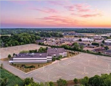
| Current Use | Vacant |
| Previous Use | Call Center |
| Zoning | B3 |
| Available for Purchase? | No |
| Contact Name | Alysse LaMarca |
| Contact Company | Industrial Commercial Properties LLC |
| Contact Phone | 440-785-5575 |
| Logistics | |
|---|---|
| RAIL | |
| Rail at Property? | No |
| PORT/AIRPORT(S) | |
| Distance to Nearest Airport | 6 miles |
| Nearest Airport Name | Akron Canton |
| ROADS | |
| Distance to nearest highway | 1.50 miles |
| Nearest highway | I-77 |
| Existing Facilities | |
|---|---|
| What is the total size of the building (sq. ft.)? | 150,000 sf |
| What is the total square footage currently configured for office (sq. ft.)? | 150,000 sf |
| Sales or Lease | Lease |
| Utilities | |
|---|---|
| ELECTRIC | |
| Electric at Site? | Yes |
| Electric Provider | Ohio Power |
| GAS | |
| Gas at Site? | Yes |
| WATER | |
| Waterline at site? | Yes |
| Water provider | Aqua Ohio |
| WASTEWATER | |
| Sewer on site? | Yes |
| Sewer Provider | Stark County Sanitary Engineer |
New
Vacant Land
Industrial
Georgetown St. NE
Canton, OH 44704
Stark County
Min Size: 90 acres
Max Size: 90 acres
Canton, OH 44704
Stark County
Min Size: 90 acres
Max Size: 90 acres
Vacant Land
Industrial
Ford Motor Works
| General Site Overview | |
|---|---|
| Site Name (if any) | Ford Motor Works |
| Site Address | Georgetown St. NE |
| City | Canton |
| County (where site is located) | Stark |
| Zip Code | 44704 |
| Latitude | 40.7957 |
| Longitude | -81.3305 |
| Site Owner | Private |
| ZoomProspector Link | View Property https://properties.zoomprospector.com/OHIO/property/admin/c2caec2d-e920-4a0d-b531-961b6429bc9e |
| Site Information | |
|---|---|
| Lot Size | 90 acres |
| Total Site Acreage | 90 acres |
| Maximum Contiguous Developable Acreage | 50 acres |
| Current Use | Vacant - CNS issued |
| Previous Use | Ford Motor Works |
| Flood Plain | No |
| Flood Plain Comments | not located in a 100-year flood zone |
| Available for Purchase? | Yes |
| Price/Acre | 15,000 |
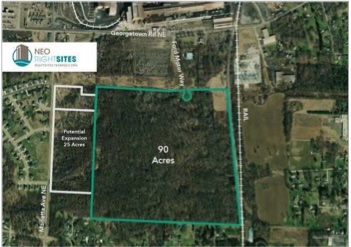
| Property Description | Heavy industrial land ( former Ford Motor works), brownfield with CNS for Ohio EPA, available for sale through Canton Community Improvement Corporation. Adjacent to major AEP substation with virtual 100 % reliability for 69 KV transmission service - 30 MW available. 1000 foot access road needed - R/W owned by city. Property has potential bedrock removal and five acres of wetlands as shown on color coded site plan. Active W&LE rail line borders east side of site. 45 contiguous acres without wetlands; 75 contiguous with wetlands. Rail can be pulled from east end of property to 45 acre footprint ( west portion of property ). potential of 25 additional acres to west. |
| Environmental/Due Diligence | |
|---|---|
| Attainment: Eight-Hour Ozone | Attainment |
| Attainment: Particulate Matter (PM 2.5) | Attainment |
| Attainment: Sulfur Dioxide (1-Hour SO2) | Attainment |
| Attainment: NOX | Attainment |
| Attainment: CO | Attainment |
| Logistics | |
|---|---|
| RAIL | |
| Rail Provider(s) | Wheeling & Lake Erie |
| Rail Spur at Property | No |
| PORT/AIRPORT(S) | |
| Distance to Nearest Port | Port of Cleveland |
| Port Name | 64 miles |
| Distance to Nearest Airport | 4 miles |
| Nearest Airport Name | Akron Canton Airport |
| Distance to Nearest International Airport | 66 miles |
| International Airport Name | Cleveland Hopkins International Airport |
| ROADS | |
| Distance to nearest highway | 1 miles |
| Nearest highway | US SR 172 |
| Distance to nearest interstate? | 4 miles |
| Nearest interstate? | I-77 |
| Land Details/Use | |
|---|---|
| Developable Acreage | 50 acres |
| Topography | Rolling |
| Greenfield/Brownfield | Brownfield |
| Previous Use | Ford Motor Works |
| Describe site neighbors | Barbco Inc., Sugardale Foods, United Rolls, Wallce Forge, United Metals Corporation and the Former Republic Steel site. |
| Utilities | |
|---|---|
| ELECTRIC | |
| Electric at Site? | Yes |
| Distance to nearest distribution electric line (<69kV)? | 0 feet |
| Nearest distribution electric line size (kV) | 12.47kV, 3-phase KVA |
| Distance to nearest transmission electric line (>69kV)? | 0 |
| Nearest transmission electric line voltage (kV) | 12.47kV V |
| Distance to nearest substation | 2,122,023 miles |
| Electric Provider | AEP |
| Additional Electric Details | 100% reliability for 69 KV transmission service - 30 MW available - Adjacent to Ohio Power/AEP Station This site is well-suited for an extensive energy user given its proximity to transmission lines and substation. |
| GAS | |
| Gas at Site? | Yes |
| Distribution Gas Line Size | 12 & 16 in |
| Distribution Gas Line Pressure | medium |
| WATER | |
| Waterline at site? | Yes |
| Distance to water line | 0 feet |
| Water line size (inches) | 16 in |
| Water Main pressure | 46 at a minimum psi |
| Water provider | City of Canton |
| Additional Water Details | The water plant capacity is upwards of 14.4 MGD. Site is well-suited for a heavy water user. |
| WASTEWATER | |
| Sewer on site? | No |
| Distance to Sewer line | 2,250 feet |
| Sewer line size | 27 in |
| Excess Sewer Capacity at site | 3,000,000 GPD |
| Sewer Provider | City of Canton |
| Additional Sewer Details | Excess plant capacity of 10,000,000 GPD |
| Cost of Infrastructure Upgrades to meet Project Demands | Cost to Extend Sewer to Site: $500,000 |
New
Vacant Land
Industrial
Fohl St SW & Sterilite St NE
Village of Navarre, OH 44662
Stark County
Min Size: 5 acres
Max Size: 172.40 acres
Village of Navarre, OH 44662
Stark County
Min Size: 5 acres
Max Size: 172.40 acres
Vacant Land
Industrial
Stark County Farm Go Site
| General Site Overview | |
|---|---|
| Site Name (if any) | Stark County Farm Go Site |
| Site Address | Fohl St SW & Sterilite St NE |
| City | Village of Navarre |
| County (where site is located) | Stark |
| Zip Code | 44662 |
| Latitude | 40.7318 |
| Longitude | -81.5095 |
| Site Owner | Stark Board of Trade, LLC managed by DeHoff Develo |
| Ownership Type | Local Foundations (Private- NonProfit) |
| ZoomProspector Link | View Property https://properties.zoomprospector.com/OHIO/property/admin/e0e1b5f6-565b-45fb-ba04-9d62590bde5b |
| Site Information | |
|---|---|
| Site Ohio Authenticated? | No |
| Lot Size | 2900' x 2000' |
| Total Site Acreage | 172 acres |
| Maximum Contiguous Developable Acreage | 143.96 |
| Divisible? | Yes |
| Current Use | Vacant Land; Shovel Ready |
| Previous Use | Agricultural |
| Zoning | Industrial |
| Flood Plain | No |
| Flood Plain Comments | Percent in Flood Plain: 0 % |
| Available for Purchase? | Yes |
| Sale Price | 75k/acre |
| Price/Acre | 75k/acre |
| Sale Terms | Negotiable |
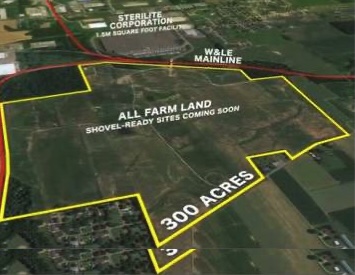
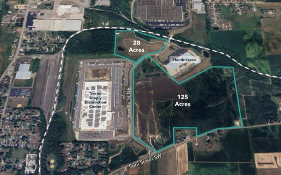
| Property Description | The Stark County Farm is a 327 acre property, with 172.40 acres remaining for development, located in the Village of Navarre. The property is zoned industrial and can handle a large industrial user. The topography has a slight roll, but no large grading issues exist. No floodplains exist on the site and there are less than 3 acres of wetlands that are avoidable or can be mitigated. All trees and stumps have been removed. Roads surrounding the property including the Sterlite Drive Bridge are capable of handling all legal loads for the state of Ohio truck traffic. Site is within close proximity to Route 21 and Route 30. The Akron-Canton airport is only a short drive away. The site is adjacent to W&LE mainline rail and trans-load facility for staging/distribution. The park has potential for heavy utility users due to surrounding infrastructure. All utilities are currently on site or in the process of being built out. All due diligence studies have been completed. Current facilities located in this property include Tractor Supplies’ largest distribution center and Hendrickson. |
| Contact Name | Bob DeHoff |
| Contact Company | DeHoff Development |
| Contact Phone | (330) 499-8153 |
| Contact Email | Email Bdehoff@dehoff.com |
| Environmental/Due Diligence | |
|---|---|
| Phase I Complete? | Yes |
| Did Phase I Recommend a Phase II (Y/N)? | No |
| Environmental Study Comments | No further action |
| Geotechnical Study Completed? | Yes |
| Wetlands Delineation Completed? | Yes |
| Jurisdictional Determination Completed? | Yes |
| Wetlands/Jurisdictional Comments | Wetlands percentage is 1% for total of 2.6 acres |
| Archeological Study Completed | Yes |
| Archeological Letter of Concurrence | Yes |
| Archeological Study Comments | No further action |
| Endangered Species Study Completed | Yes |
| Endangered Species letter from US Fish and Wildlife | Yes |
| Endangered Species Comments | No further action and in full compliance |
| Full Attainment | Yes |
| Attainment: Eight-Hour Ozone | Attainment |
| Attainment: Particulate Matter (PM 2.5) | Attainment |
| Attainment: Sulfur Dioxide (1-Hour SO2) | Attainment |
| Attainment: Lead | Attainment |
| Attainment: NOX | Attainment |
| Attainment: CO | Attainment |
| Separate Mineral Rights? | No |
| Separate Mineral Rights Description | Mineral Rights do not transfer |
| Logistics | |
|---|---|
| RAIL | |
| Rail at Property? | Yes |
| Distance to rail | 0 feet |
| Rail Provider(s) | Wheeling & Lake Erie |
| Rail Type | Class 2 |
| Rail Spur at Property | No |
| PORT/AIRPORT(S) | |
| Distance to Nearest Port | 60 miles |
| Port Name | Cleveland |
| Distance to Nearest Airport | 20 miles |
| Nearest Airport Name | Akron Canton Airport |
| Distance to Nearest International Airport | 62 miles |
| International Airport Name | Cleveland Hopkins |
| ROADS | |
| Distance to nearest highway | 1.50 miles |
| Nearest highway | SR 21 |
| Is this a 4-lane highway? | Yes |
| Distance to nearest interstate? | 9 miles |
| Nearest interstate? | I-77 |
| Land Details/Use | |
|---|---|
| Developable Acreage | 172.40 acres |
| Topography | flat to gentle roll |
| Previous Use | Farming |
| Multi tenant (park) / stand alone | Multi-tenant |
| Describe site neighbors | Hendrickson built a 200,000 sf manufacturing facility in the park. Nearby businesses include Sterilite, Shearer's Food, and Baker Hughes. Tractor Supply is constructing a more than 895,000-square-foot warehouse at 3001 Sterilite St. NE. |
| Time to shovel ready | Fully shovel ready with all major due diligence completed |
| Utilities | |
|---|---|
| ELECTRIC | |
| Electric at Site? | Yes |
| Distance to nearest distribution electric line (<69kV)? | On site |
| Nearest distribution electric line size (kV) | 69 and 12.5 KVA |
| Distribution Excess Capacity (MW) | 4MW (First Energy will need to confirm) |
| Distance to nearest transmission electric line (>69kV)? | On site |
| Nearest transmission electric line voltage (kV) | 277/480 V |
| Redundant Power? | Yes |
| Distance to nearest substation | 3.4 miles |
| Electric Provider | First Energy |
| Additional Electric Details | The Campus is supplied with power from a substation located approximately 3.4 miles away. The substation is supplied by (2) separate 115 kV transmission lines. The Substation has (2) transformers each with a 20 MVA base rating and a forced oil & air rating of 37 MVA, with 30 MVA of available base load capacity and 64 MVA of available FOA capacity. The Campus is served by (2) 22.8 kV, 3 phase distributions circuits (20 MVA each). |
| Scope and Timeline for Infrastructure Upgrades | The Campus substation has sufficient available capacity to serve all phases of the Project. |
| GAS | |
| Gas at Site? | Yes |
| Distance to Natural Gas Distribution Line | On site; less than 1000' from parcel |
| Distribution Gas Line Size | 8 inch |
| Distribution Gas Line Pressure | 65 psi |
| Gas excess distribution capacity at site | TBD; Dominion will need to cofirm |
| Distance to Natural Gas Transmission Line | 0 feet |
| Natural Gas Provider | Dominion East Ohio |
| Additional Gas Details | 8 inch 65 psi line extends into the north side of the park |
| WATER | |
| Waterline at site? | Yes |
| Distance to water line | On site; less than 500' from parcel |
| Water line size (inches) | 12 inch |
| Water Main pressure | 205 psi Village of Navarre; 85 psi Aqua Ohio |
| Excess Water Capacity at Site (GPD) | 950,000 Village of Navarre; 1M GPD Aqua Ohio |
| Water provider | City of Navarre on site / Aqua Ohio 1500' north |
| Additional Water Details | Navarre water available up to 950,000 MGD at 205 psi with current water tower on site. |
| Scope and Timeline for Infrastructure Upgrades | Site offers robust water and should be able to accommodate this project without issue |
| WASTEWATER | |
| Sewer on site? | Yes |
| Distance to Sewer line | On site; less than 500' from parcel |
| Sewer line size | 27 inch |
| Excess Sewer Capacity at site | 300,000 GPD |
| Sewer Provider | Village of Navarre |
| Additional Sewer Details | 300,000 gpd available to 27 inch navarre trunk at west side of site. Up to 2 MGD available with the construction of a force-main and one mile of 12 inch pipe to Massillon interceptor to north. Sewer lateral extension from new road installation in place as of 10/19. |
| Scope and Timeline for Infrastructure Upgrades | Site offers robust wastewater support and should be able to accommodate this project without issue. |
| FIBER | |
| Fiber Service to Site? | Yes |
| Distance to Fiber Line | 0 feet |
| Fiber Provider | MCTV and / or AT&T |
| Telecom Provider | MCTV or AT&T |
| Additional Fiber/Telecom Details | Fiber extension / land lines extended into northern end of park 10/19 |
Vacant Land
Industrial
Chamber Avenue, Canton, Ohio 44706 (close to 4111 CHAMBER AVE SW CANTON OH 44706)
Canton, OH 44706
Stark County County
Min Size: 3 acres
Max Size: 86.50 acres
Canton, OH 44706
Stark County County
Min Size: 3 acres
Max Size: 86.50 acres
Vacant Land
Industrial
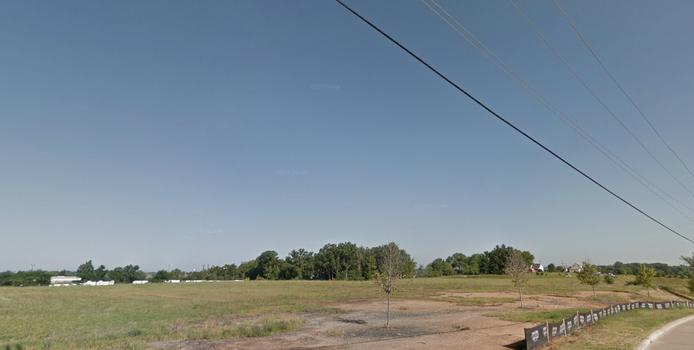
Mills Business Park
| General Site Overview | |
|---|---|
| Site Name (if any) | Mills Business Park |
| Site Address | Chamber Avenue, Canton, Ohio 44706 (close to 4111 CHAMBER AVE SW CANTON OH 44706) |
| City | Canton |
| County (where site is located) | Stark County |
| Zip Code | 44706 |
| Latitude | 40.7500 |
| Longitude | -81.4252 |
| Site Owner | Canton Commerce Development |
| Ownership Type | Private |
| ZoomProspector Link | View Property https://properties.zoomprospector.com/OHIO/property/admin/83891f5e-30cb-41a6-8c40-ec8e926c5a1e |
| Site Information | |
|---|---|
| Site Ohio Authenticated? | No |
| Lot Size | 86.2 acres |
| Total Site Acreage | 86 acres |
| Maximum Contiguous Developable Acreage | 45 acres |
| Divisible? | Yes |
| Current Use | Industrial Park |
| Previous Use | Agricultural Land |
| Zoning | Industrial |
| Flood Plain | No |
| Flood Plain Comments | N/A |
| Available for Purchase? | Yes |
| Sale Price | $75000-$100000 per acre depending on site location |
| Price/Acre | $75000-$100000 per acre depending on site location |
| Sale Terms | Negotiable |
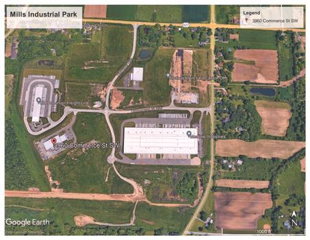
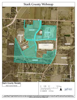
| Property Description | Mills Industrial Park is a 142-acre Class A industrial park in the City of Canton, originally platted in 2008. Approximately 86 acres remain available for development, with individual lots up to approximately 20 acres. The site is fully shovel-ready and located one mile west of Interstate 77 (I-77) via the Faircrest Road interchange. The park is owned by Canton Commerce Development, a local not-for-profit entity, and is managed by DeHoff Development Company. Significant upfront infrastructure investment has been completed, including mass grading and topsoil removal to create level building pads, off-site detention basins and storm sewers eliminating the need for on-site detention, and extra-wide industrial-strength concrete roadways. All roads and utilities are in place, and construction can begin immediately upon issuance of building permits, regardless of season. Protective covenants ensure compatible industrial uses. |
| Contact Name | Bob DeHoff |
| Contact Company | DeHoff Development |
| Contact Phone | 330-499-8153 |
| Contact Email | Email Bdehoff@dehoff.com |
| Environmental/Due Diligence | |
|---|---|
| Phase I Complete? | Yes |
| Did Phase I Recommend a Phase II (Y/N)? | No |
| Environmental Study Comments | No further action and in full compliance |
| Geotechnical Study Completed? | Yes |
| Wetlands Delineation Completed? | Yes |
| Jurisdictional Determination Completed? | Yes |
| Wetlands/Jurisdictional Comments | No further action and in full compliance |
| Archeological Study Completed | Yes |
| Archeological Letter of Concurrence | Yes |
| Archeological Study Comments | No further action and in full compliance |
| Endangered Species Study Completed | Yes |
| Endangered Species letter from US Fish and Wildlife | Yes |
| Endangered Species Comments | No further action and in full compliance |
| Full Attainment | Yes |
| Attainment: Eight-Hour Ozone | Attainment |
| Attainment: Particulate Matter (PM 2.5) | Attainment |
| Attainment: Sulfur Dioxide (1-Hour SO2) | Attainment |
| Attainment: Lead | Attainment |
| Attainment: NOX | Attainment |
| Attainment: CO | Attainment |
| Separate Mineral Rights? | No |
| Separate Mineral Rights Description | Mineral Rights do not transfer |
| Logistics | |
|---|---|
| RAIL | |
| Rail at Property? | No |
| Distance to rail | N/A |
| Rail Provider(s) | N/A |
| Rail Type | N/A |
| Rail Spur at Property | No |
| Dual Rail | No |
| PORT/AIRPORT(S) | |
| Distance to Nearest Port | 60 miles |
| Port Name | Port of Cleveland |
| Distance to Nearest Airport | 15 miles |
| Nearest Airport Name | Akron-Canton Airport |
| Distance to Nearest International Airport | 60 miles |
| International Airport Name | Cleveland Hopkins |
| ROADS | |
| Distance to nearest highway | Less than 2 miles |
| Nearest highway | I-77 |
| Is this a 4-lane highway? | Yes |
| Distance to nearest interstate? | Less than 2 miles |
| Nearest interstate? | I-77 |
| Land Details/Use | |
|---|---|
| Developable Acreage | 86.52 acres |
| Configuration | Flexible parcel configurations. |
| Topography | Flat, Graded and development ready |
| Multi tenant (park) / stand alone | Multi-tenant |
| Describe site neighbors | Current tenants in the park: Medline, G.E oil and Gas, Dominion Frieght Lines and I2R Power Cable Company |
| Time to shovel ready | Fully shovel ready with mass grading completed |
| Utilities | |
|---|---|
| ELECTRIC | |
| Electric at Site? | Yes |
| Distance to nearest distribution electric line (<69kV)? | On site |
| Nearest distribution electric line size (kV) | 12.5 KVA, 3 phase |
| Distribution Excess Capacity (MW) | AEP will need to confirm |
| Distance to nearest transmission electric line (>69kV)? | On site |
| Nearest transmission electric line voltage (kV) | 12.5 KVA |
| Redundant Power? | Yes |
| Distance to nearest substation | Less than 1 mile |
| Electric Provider | AEP |
| Scope and Timeline for Infrastructure Upgrades | Scope of work for infrastructure improvements required to meet Project Demands: The substation on the site has sufficient available capacity to serve all phases of the project. Timeline for Infrastructure Upgrades to meet Project Demands: TBD - Load study will provide better clarity. |
| Cost of Infrastructure Upgrades to meet Project Demands | TBD |
| GAS | |
| Gas at Site? | Yes |
| Distance to Natural Gas Distribution Line | On site |
| Distribution Gas Line Size | 12 inch |
| Distribution Gas Line Pressure | 110-120 psi |
| Gas excess distribution capacity at site | 10,000 M3 |
| Distance to Natural Gas Transmission Line | At site boundary |
| Natural Gas Provider | Dominion East Ohio Gas |
| Scope and Timeline for Infrastructure Upgrades | Scope of work for infrastructure improvements required to meet Project Demands: The site should have enough gas to fully support this project but will need confirmation from Enbridge Gas. Timeline for Infrastructure Upgrades to meet Project Demands: TBD |
| Cost of Infrastructure Upgrades to meet Project Demands | TBD |
| WATER | |
| Waterline at site? | Yes |
| Distance to water line | On site |
| Water line size (inches) | 10 inch |
| Water Main pressure | 36-65 psi |
| Excess Water Capacity at Site (GPD) | TBD |
| Water provider | City of Canton |
| Additional Water Details | This site and the City of Canton's water infrastructure can fully support this project's expected water consumption rate. |
| Scope and Timeline for Infrastructure Upgrades | Scope of work for infrastructure improvements required to meet Project Demands: Site has ample water that can fully support this project. Timeline for Infrastructure Upgrades to meet Project Demands: TBD |
| Cost of Infrastructure Upgrades to meet Project Demands | TBD |
| WASTEWATER | |
| Sewer on site? | Yes |
| Distance to Sewer line | On site |
| Sewer line size | 6-18 inch |
| Excess Sewer Capacity at site | To be provided |
| Sewer Provider | City of Canton |
| Additional Sewer Details | This site and the City of Canton's waste water infrastructure can fully support this project's expected waste water discharge rate. |
| Scope and Timeline for Infrastructure Upgrades | Scope of work for infrastructure improvements required to meet Project Demands: Site has ample waste water capacity to support this project. Timeline for Infrastructure Upgrades to meet Project Demands: TBD |
| Cost of Infrastructure Upgrades to meet Project Demands | TBD |
| FIBER | |
| Fiber Service to Site? | Yes |
Vacant Land
Industrial
MAIN ST W ALLIANCE OH 44601 (next to 2155 MAIN ST NW ALLIANCE OH 44601)
Alliance, OH 44601
Stark County
Min Size: 5 acres
Max Size: 51.40 acres
Alliance, OH 44601
Stark County
Min Size: 5 acres
Max Size: 51.40 acres
Vacant Land
Industrial
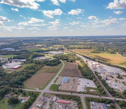
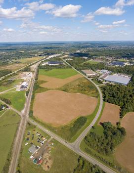
Alliance Commerce Park
| General Site Overview | |
|---|---|
| Site Name (if any) | Alliance Commerce Park |
| Site Address | MAIN ST W ALLIANCE OH 44601 (next to 2155 MAIN ST NW ALLIANCE OH 44601) |
| City | Alliance |
| County (where site is located) | Stark |
| Zip Code | 44601 |
| Latitude | 40.9129 |
| Longitude | -81.1495 |
| Site Owner | Alliance Commerce Park, LLC |
| Ownership Type | Private |
| ZoomProspector Link | View Property https://properties.zoomprospector.com/OHIO/property/admin/91eb8158-bda5-443f-a569-b4cf050f31cf |
| Site Information | |
|---|---|
| Site Ohio Authenticated? | No |
| Lot Size | 67 acres |
| Total Site Acreage | 51.3 acres |
| Maximum Contiguous Developable Acreage | 51.3 acres |
| Divisible? | Yes |
| Current Use | Vacant Land; Shovel Ready |
| Previous Use | Agricultural |
| Zoning | Industrial |
| Flood Plain | No |
| Flood Plain Comments | 0 percent |
| Available for Purchase? | Yes |
| Sale Price | 75k/acre |
| Price/Acre | 75k/acre |
| Sale Terms | Negotiable |
| Property Description | Class A industrial park with northern border against Norfolk and Southern mainline. Restrictive covenants in place. Site is shovel ready and provides easy access to US 62, a four-lane highway that connects to I-77. Current occupants within the Alliance Commerce Park include IML, Mac Trailer, Robertson’s Heating Distribution, and Trilogy Plastics. |
| Contact Name | Rick Baxter |
| Contact Company | Alliance Area Development |
| Contact Phone | 330-823-0700 |
| Contact Email | Email rbaxter@allianceadf.com |
| Environmental/Due Diligence | |
|---|---|
| Phase I Complete? | Yes |
| Did Phase I Recommend a Phase II (Y/N)? | No |
| Environmental Study Comments | No further action |
| Geotechnical Study Completed? | Yes |
| Wetlands Delineation Completed? | Yes |
| Jurisdictional Determination Completed? | Yes |
| Wetlands/Jurisdictional Comments | No wetlands |
| Archeological Study Completed | Yes |
| Archeological Letter of Concurrence | Yes |
| Archeological Study Comments | No further action |
| Endangered Species Study Completed | Yes |
| Endangered Species letter from US Fish and Wildlife | Yes |
| Endangered Species Comments | No further action and in full compliance |
| Full Attainment | Yes |
| Attainment: Eight-Hour Ozone | Attainment |
| Attainment: Particulate Matter (PM 2.5) | Attainment |
| Attainment: Sulfur Dioxide (1-Hour SO2) | Attainment |
| Attainment: Lead | Attainment |
| Attainment: NOX | Attainment |
| Attainment: CO | Attainment |
| Separate Mineral Rights? | No |
| Separate Mineral Rights Description | Mineral Rights do not transfer |
| Logistics | |
|---|---|
| RAIL | |
| Rail at Property? | Yes |
| Distance to rail | 0 feet |
| Rail Provider(s) | Norfolk Southern |
| Rail Type | Class 1 |
| Rail Spur at Property | No |
| PORT/AIRPORT(S) | |
| Distance to Nearest Port | 60 miles |
| Port Name | Port of Cleveland |
| Distance to Nearest Airport | 15 miles |
| Nearest Airport Name | Akron Canton Airport |
| Distance to Nearest International Airport | 64 miles |
| International Airport Name | Cleveland Hopkins International Airport |
| ROADS | |
| Distance to nearest highway | 1.5 miles |
| Nearest highway | US 62 |
| Is this a 4-lane highway? | Yes |
| Distance to nearest interstate? | 15 miles |
| Nearest interstate? | I-77 |
| Land Details/Use | |
|---|---|
| Developable Acreage | 51.37 acres |
| Topography | Flat and development ready |
| Previous Use | Agricultural |
| Multi tenant (park) / stand alone | Multi-tenant |
| Describe site neighbors | Businesses within 2 miles of site: Tireteam Trilogy Plastics Terry's Tire Town All-Pro RV Marc's Walmart Supercenter ALDI Holiday Inn Express & Suites Alliance Heart of Gold Tattoo Lowe's Taco Bell Starbucks Bob Evans Bellstores/Marathon/Subway Tractor Supply Co. Applebee's Grill + Bar Staples Coastal Pet Products |
| Time to shovel ready | Fully shovel ready |
| Utilities | |
|---|---|
| ELECTRIC | |
| Electric at Site? | Yes |
| Distance to nearest distribution electric line (<69kV)? | On site |
| Nearest distribution electric line size (kV) | 69 and 12.5 KVA |
| Distribution Excess Capacity (MW) | 4MW (First Energy will need to confirm) |
| Distance to nearest transmission electric line (>69kV)? | On site |
| Nearest transmission electric line voltage (kV) | 277/480 kV |
| Redundant Power? | Yes |
| Distance to nearest substation | 4 miles |
| Electric Provider | First Energy |
| Additional Electric Details | A load study and/or more information is needed to determine if the 2nd phase can be served off of the distribution system or will need to be served off of the transmission system. |
| Scope and Timeline for Infrastructure Upgrades | A load study will need to be conducted to confirm, but confident that this site can meet this project's energy demands and timeline. |
| GAS | |
| Gas at Site? | Yes |
| Distance to Natural Gas Distribution Line | On site |
| Distribution Gas Line Size | 6 inch |
| Distribution Gas Line Pressure | 45 psi |
| Gas excess distribution capacity at site | TBD; Dominion and Columbiana will need to cofirm |
| Distance to Natural Gas Transmission Line | 0 feet |
| Natural Gas Provider | Dominion |
| Additional Gas Details | Dominion - 1-Up size around 3,450ft of existing 3" Steel to 8" PLMD ( L#877 along Aebi Ave. ) 2-Add new regulator station from the G/A line at the intersection of Edison St. and Aebi Ave. This station upgrade is at a minimum $550,000. Columbia - The ~4,400 mainline extension would start at the intersection of W Main St/Sawburg Rd and run along W Main St to Foreman’s meter location. |
| WATER | |
| Waterline at site? | Yes |
| Distance to water line | On site |
| Water line size (inches) | 12 inch |
| Water Main pressure | 90 psi |
| Excess Water Capacity at Site (GPD) | 2.5M GPD |
| Water provider | City of Alliance |
| Scope and Timeline for Infrastructure Upgrades | Site offers robust water and should be able to accommodate this project without issue. |
| WASTEWATER | |
| Sewer on site? | Yes |
| Distance to Sewer line | On site |
| Sewer line size | 12 inch |
| Excess Sewer Capacity at site | 1.6M GPD |
| Sewer Provider | City of Alliance |
| Scope and Timeline for Infrastructure Upgrades | Site offers robust wastewater support and should be able to accommodate this project without issue. |
| FIBER | |
| Fiber Service to Site? | Yes |
| Distance to Fiber Line | 0 feet |
| Fiber Provider | AT&T |
| Telecom Provider | AT&T |
Vacant Land
Industrial
Energy Drive
Louisville, OH 44641
Stark County
Min Size: 7 acres
Max Size: 170 acres
Louisville, OH 44641
Stark County
Min Size: 7 acres
Max Size: 170 acres
Vacant Land
Industrial
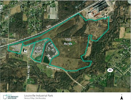
Louisville Energy Park
| General Site Overview | |
|---|---|
| Site Name (if any) | Louisville Energy Park |
| Site Address | Energy Drive |
| City | Louisville |
| County (where site is located) | Stark |
| Zip Code | 44641 |
| Latitude | 40.8243 |
| Longitude | -81.2819 |
| Site Owner | Groffre Investments |
| Ownership Type | Private |
| ZoomProspector Link | View Property https://properties.zoomprospector.com/OHIO/property/admin/0d88392f-b1ca-4dbc-8860-20fa2a67ae54 |
| Site Information | |
|---|---|
| Site Ohio Authenticated? | No, but in the process |
| Lot Size | 170 acres |
| Total Site Acreage | 170 acres |
| Maximum Contiguous Developable Acreage | 150 acres |
| Divisible? | Yes |
| Current Use | Industrial |
| Previous Use | Light Industrial/ Vacant Land |
| Zoning | Industrial |
| Flood Plain | No |
| Flood Plain Comments | No land in flood plain |
| Available for Purchase? | Yes |
| Sale Price | $50-100k depending on location within site |
| Price/Acre | $50-100k depending on location within site |
| Sale Terms | Negotiable |
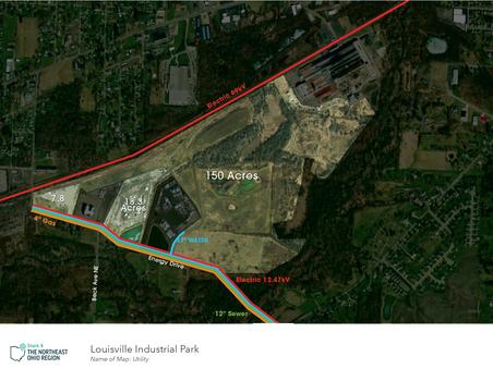
| Property Description | This site has over 170 contiguous, developable acres with a total of 261 acres on site. Portions of the site are shovel ready and have been improved with slag/gravel, fence, and lights, asking price is $125,000 for the improved acreage and Lots 1 and 2, $50,000 per acre in for unimproved Lot 3. The site is well suited for an end-user seeking unparalleled rail access and is ideal for metals and heavy industry. Parts of the site have already been graded for rail, and there is an existing track plan that was developed with and approved by Norfolk Southern, whose Canton Yard is a little over a mile away. Significant due diligence including geotechnical, wetland delineation and mitigation, and Phase I environmental has already been completed. Onsite detention for entire park has been already completed. Home of former Chesapeake/Encino Energy Corp office. Access to a skilled workforce: • 247k + workers in a 30-minute drive time • Above average employment concentration in the following: Metal & Plastic Workers, Assemblers & Fabricators, Food Processing Workers, Material Distributing Workers. • Top Industries within 30-minute drive: Heavy Construction, Machinery & Equipment Manufacturing, Metals Fabrication, Chemicals, Rubbers& Plastics, and Oil and Gas. |
| Environmental/Due Diligence | |
|---|---|
| Phase I Complete? | Yes |
| Did Phase I Recommend a Phase II (Y/N)? | Yes |
| Phase II Complete? | Yes |
| Environmental Study Comments | Four minor RECs found on site - Already remediated and received CNS and no further action from EPA as to 210 acres. |
| Geotechnical Study Completed? | Yes |
| Wetlands Delineation Completed? | Yes |
| Jurisdictional Determination Completed? | Yes |
| Wetlands/Jurisdictional Comments | Nationwide permit issued, mitigation completed. 3.3 acres have been identified; would not adversely impact building. |
| Archeological Study Completed | Yes |
| Archeological Letter of Concurrence | Yes |
| Archeological Study Comments | No further action |
| Endangered Species Study Completed | Yes |
| Endangered Species letter from US Fish and Wildlife | Yes |
| Endangered Species Comments | No further action and in full compliance |
| Full Attainment | Yes |
| Attainment: Eight-Hour Ozone | Attainment |
| Attainment: Particulate Matter (PM 2.5) | Attainment |
| Attainment: Sulfur Dioxide (1-Hour SO2) | Attainment |
| Attainment: Lead | Attainment |
| Attainment: NOX | Attainment |
| Attainment: CO | Attainment |
| Separate Mineral Rights? | No |
| Separate Mineral Rights Description | Mineral Rights do not transfer |
| Logistics | |
|---|---|
| RAIL | |
| Rail at Property? | Yes |
| Rail Provider(s) | Norfork Sourthern |
| Rail Type | Class I |
| Rail Spur at Property | No |
| PORT/AIRPORT(S) | |
| Distance to Nearest Port | 60 miles |
| Port Name | Port of Cleveland |
| Distance to Nearest Airport | 15 miles |
| Nearest Airport Name | Akron Canton Regional Airport |
| Distance to Nearest International Airport | 60 miles |
| International Airport Name | Cleveland Hopkins International Airport |
| ROADS | |
| Distance to nearest highway | 3 miles |
| Nearest highway | SR-62 |
| Is this a 4-lane highway? | Yes |
| Distance to nearest interstate? | 7 miles |
| Nearest interstate? | I-77 |
| Land Details/Use | |
|---|---|
| Developable Acreage | 170 acres |
| Topography | Level, Generally flat with portions pre graded |
| Previous Use | Light Industrial/ Vacant Land |
| Multi tenant (park) / stand alone | Multi-tenant |
| Describe site neighbors | Top Employers Proximate: The TimkenCompany, HP Products, Atlas Technologies, Fresh Mark Inc, Sugardale Foods, Hendrickson TrailerCompany, Biery Cheese, United Rolls, Union MetalCorp. |
| Time to shovel ready | Portions shovel ready with site improvements completed |
| Utilities | |
|---|---|
| ELECTRIC | |
| Electric at Site? | Yes |
| Distance to nearest distribution electric line (<69kV)? | On site |
| Nearest distribution electric line size (kV) | 12.47kV |
| Distribution Excess Capacity (MW) | 7MW (AEP will need to confirm) |
| Distance to nearest transmission electric line (>69kV)? | On site |
| Nearest transmission electric line voltage (kV) | 69kV |
| Redundant Power? | Yes |
| Distance to nearest substation | .6 miles |
| Electric Provider | AEP Ohio |
| Additional Electric Details | The Campus is supplied with power from a substation located approximately 3.4 miles away. The substation is supplied by (2) separate 115 kV transmission lines. The Substation has (2) transformers each with a 20 MVA base rating and a forced oil & air rating of 37 MVA, with 30 MVA of available base load capacity and 64 MVA of available FOA capacity. The Campus is served by (2) 22.8 kV, 3 phase distributions circuits (20 MVA each). |
| Scope and Timeline for Infrastructure Upgrades | Scope of work for infrastructure improvements required to meet Project Demands: The substation has sufficient available capacity to serve all phases of the Project, however AEP will need to verify with a load study. Timeline for Infrastructure Upgrades to meet Project Demands: TBD-AEP will be able to provide more clarity upon completion of a load study. |
| GAS | |
| Gas at Site? | Yes |
| Distance to Natural Gas Distribution Line | On site |
| Distribution Gas Line Size | 4" |
| Distribution Gas Line Pressure | 50-70 PSI |
| Gas excess distribution capacity at site | TBD; Dominion will need to confirm |
| Distance to Natural Gas Transmission Line | On site |
| Natural Gas Provider | Dominion |
| Additional Gas Details | To Site Boundary - along Beck/Energy Drive |
| Scope and Timeline for Infrastructure Upgrades | TBD |
| Cost of Infrastructure Upgrades to meet Project Demands | TBD |
| WATER | |
| Waterline at site? | Yes |
| Distance to water line | On site |
| Water line size (inches) | 12" |
| Water Main pressure | 65 PSI |
| Excess Water Capacity at Site (GPD) | 200,000 GPD |
| Water provider | City of Louisville |
| Additional Water Details | Additional 1,300,000 gallons raw water available. The city can provide 1.5 MGD in raw water by extending our current raw water line to this location. With significant upgrades to the water treatment plant and distribution system, we will be able to provide 2 MGD to the site. |
| Scope and Timeline for Infrastructure Upgrades | Scope of work for infrastructure improvements required to meet Project Demands: Site offers robust water and should be able to accommodate this project without issue. Timeline for Infrastructure Upgrades to meet Project Demands: TBD |
| Cost of Infrastructure Upgrades to meet Project Demands | TBD |
| WASTEWATER | |
| Sewer on site? | Yes |
| Distance to Sewer line | On site |
| Sewer line size | 12" |
| Excess Sewer Capacity at site | 2,000,000 GPD |
| Sewer Provider | City of Louisville |
| Additional Sewer Details | The city has made major renovations to the plant over the last couple of years. The city is planning another renovation that will help with expanding the wastewater treatment plant capacity. Site offers robust wastewater support and should be able to accommodate this project without issue. |
| Scope and Timeline for Infrastructure Upgrades | TBD |
| Cost of Infrastructure Upgrades to meet Project Demands | TBD |
| FIBER | |
| Fiber Service to Site? | Yes |
| Fiber Provider | AT&T |
| Telecom Provider | AT&T |
Contact Us
Considering moving your business to Stark County? Contact us and we'll help make you make your move. We have the connections to introduce you to all the right people and offer strong incentives. We look forward to hearing from you.